
BEGINNING THIS MONTH and continuing through future issues, I’ll explore common questions surrounding the permissions, compliance requirements, and other considerations that are needed to legally operate at various types of flying sites. Whether you’re investigating the feasibility of a new field, planning an event, or confirming that you’re squared away with local park management, this series will aim to help you navigate those decisions with clarity.
For the purposes of the example scenarios in this series, let’s assume that our pilot has already met the baseline expectations for recreational flight: They have proof of passing The Recreational UAS Safety Test (TRUST), have maintained current FAA registration when applicable, have access to a Remote ID module, and follow an approved safety code from an authorized community-based organization (CBO) such as AMA. From there, determining what else is needed comes down to permissions and compliance. See the link to all recreational requirements and information about CBOs in "Sources" at the end of the article.
This first installment focuses on the most common pairing of land use and airspace. I’ll start with straightforward scenarios and gradually work toward more complex ones, covering additional questions about Remote ID, FAA registration nuances, Large Model Aircraft Program considerations, and altitude limitations.
Scenario: Uncontrolled Airspace, Private Land
A quick refresher on uncontrolled (Class G) airspace will help set the foundation for the example. Later installments will explore controlled airspace (Class A, B, C, D, and portions of E) and more detailed Class G nuances.
Unlike controlled airspace, Class G airspace is not actively managed by an air traffic control (ATC) tower. Recreational operations in Class G airspace must remain at or below 400 feet above ground level (AGL), unless a site or pilot has been specifically authorized for higher altitudes. The following image from the FAA’s UAS Facility Map visually illustrates where the circular uncontrolled airspace surrounding the ATC tower transitions into Class G airspace, which comprises the remainder of the map.
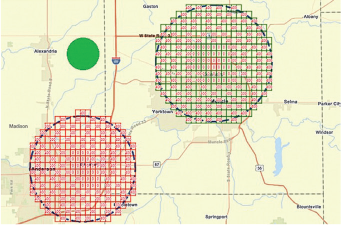
For this example, let’s assume that our pilot owns a parcel of private land from which they will take off, fly, and land, located within the green shaded area in the upper left corner. With those details in mind—Class G airspace, private land, and the pilot’s baseline requirements—we can now evaluate the major items needed for permission and compliance.
Permissions to Consider
- No additional landowner permission is needed since the pilot owns the property.
Compliance Requirements to Consider
- Operate at or below 400 feet AGL.
- Aircraft of more than 0.55 pounds are registered with the FAA and marked accordingly.
- Remote ID module installed and active.
- Pilot follows an approved safety code from an authorized CBO such as AMA.
Variation: Established FRIA
If the same land was instead an established club flying field with an FAARecognized Identification Area (FRIA), the list of items above would remain almost the same, but the pilot would no longer need a Remote ID module when operating there.
Changed Compliance Requirements
- Remote ID is no longer required at this location while the FRIA remains active.
This small variation makes a huge difference for daily operations, but we should investigate more complex issues as well. What if the flight box extends over the properties of multiple neighbors? What if the field is located in two different airspace classes? When can you fly above 400 feet AGL?
As I tackle these questions and more, members are encouraged to submit specific scenarios or questions to me at lucasr@modelaircraft.orgfor personal assistance and for further clarity in the next article.
SOURCES:
FAA UAS Facility Map


Comments
Add new comment